Sandeep Gautam
I'm a Geomatics Engineer
About
Geomatics Engineer with experience in GIS, remote sensing, hydrological analysis, and land use-land cover modeling. I build practical geospatial solutions using UAV, LiDAR, satellite imagery, and GeoAI workflows including U-Net and YOLO-based feature extraction.
Geomatics Engineer & GeoAI Practitioner
Focused on turning complex geospatial and AI outputs into decision-ready insights for planning, risk assessment, and environmental management.
- Phone: +977 9869337930
- Email: gtmsandeep2@gmail.com
- City: Pokhara, Nepal
- GitHub: github.com/sanme10
- Degree: Bachelor in Geomatics Engineering
- University: Tribhuvan University
- Freelance: Available
- Languages: Nepali, English, Hindi
I have contributed to reservoir sedimentation studies, flood risk assessment, and large-scale geospatial data standardization projects for international clients, while continuing to expand capabilities in deep learning for remote sensing.
Key Achievements
Delivering high-precision geospatial data, AI-driven insights, and engineering-grade analysis
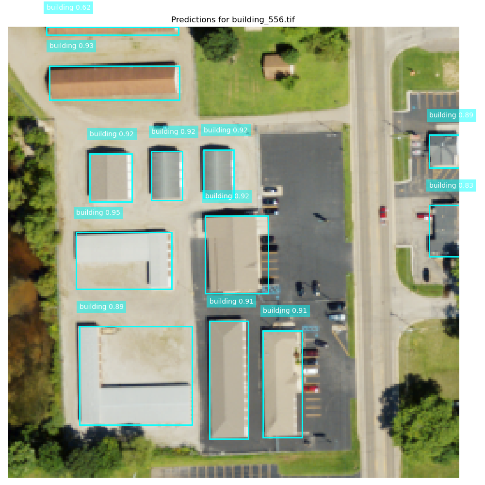
96.1%
Detection Accuracy
YOLOv8 Building Identification
0.93 IoU
GeoAI Segmentation
U-Net Feature Extraction
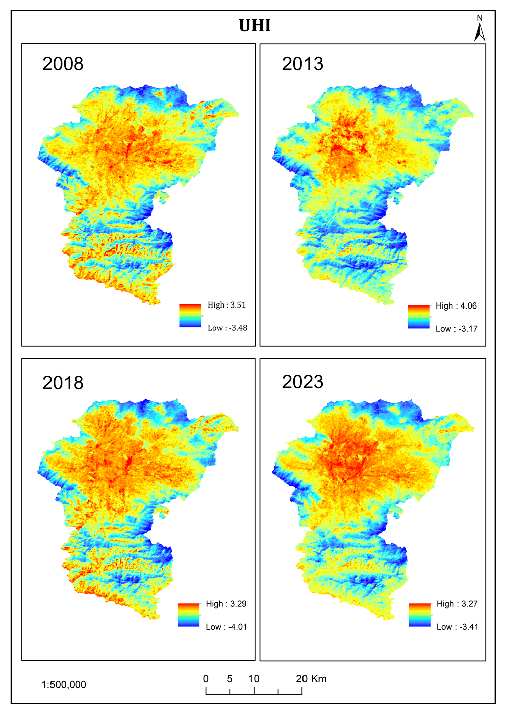
15 Years Data
Urban Heat Island
Spatio-temporal Analysis & Prediction
LiDAR
Point Cloud Processing
High-precision DTM & DSM Generation
1 million+ ft
Road Network
Digitized with ~1 ft accuracy
7,000+
Address Points
Standardized for GIS-ready datasets
Skills
Core capabilities in geospatial analysis, GeoAI modeling, field surveys, and technical communication.
Resume
Academic background in geomatics engineering with hands-on experience in remote sensing, spatial analytics, and AI-assisted mapping workflows.
Summary
Sandeep Gautam
Geomatics Engineer delivering GIS, remote sensing, and GeoAI solutions for infrastructure, environment, and risk planning use-cases.
- Pokhara, Nepal
- +977 9869337930
- gtmsandeep2@gmail.com
Education
Bachelor in Geomatics Engineering
2021 - 2025
Pashchimanchal Campus, Tribhuvan University, Pokhara
Aggregate: 74.81%. Coursework included GIS, cartography, remote sensing, photogrammetry, satellite positioning, and Python programming.
Higher Secondary Education (Science)
2018 - 2020
SOS Hermann Gmeiner School, Gandaki
CGPA: 3.58 with focus on mathematics and science foundations for engineering studies.
Professional Experience
Geomatics Engineer
Apr 2025 - Present
Geo3D Modelling, Kathmandu, Nepal
- Processed UAV, DGPS, LiDAR, and bathymetry datasets for mapping and monitoring.
- Contributed to sedimentation studies of Phewa and Kulekhani reservoirs.
- Led QA/QC, spatial validation, and attribute correction for production datasets.
Freshwater and Community Conservation Extern
Jul 2025 - Sep 2025
National Geographic Society + The Nature Conservancy (Remote)
- Performed landscape and gap analysis for freshwater issues around Phewa Lake.
- Conducted participatory mapping with stakeholders and synthesized findings into a StoryMap dashboard.
Freelance GIS Analyst / Consultant
2023 - Present
Remote (US & Europe Clients)
- Standardized 7,000+ address points into topologically clean GeoPackage datasets.
- Digitized 1 million+ feet of roadway features with high positional quality control.
- Delivered integration-ready geospatial layers through strict QA/QC workflows.
Projects
Selected projects in GeoAI, urban climate analysis, freshwater conservation, sedimentation, and flood risk modeling.
Services
Professional geospatial and GeoAI support for research, planning, and implementation teams.
GIS Analysis & Mapping
Spatial analysis, base map production, and geodatabase preparation for project workflows.
UAV & LiDAR Processing
Drone and LiDAR data processing for terrain, monitoring, and high-accuracy mapping outputs.
GeoAI Model Development
Object detection and segmentation pipelines using deep learning for automated feature extraction.
Hydrology & Flood Studies
Runoff analysis, floodplain mapping, and risk zoning with GIS, RS, and HEC-RAS workflows.
QA/QC for Geospatial Data
Topology checks, attribute normalization, and validation for integration-ready deliverables.
StoryMaps & Reporting
Interactive spatial narratives and reporting assets for technical and non-technical audiences.
Contact
Open to full-time roles, research collaborations, and freelance GIS or GeoAI projects.
Address
Pokhara-14, Nepal
Call
+977 9869337930
gtmsandeep2@gmail.com